Tag Archive for: climbing

Madison Gulf

The Presidential Range, NH

Of the UP! & Ova…….. aka; Holy F*%*!

by Alan Cattabriga

Madison Gulf from the approch

Madison Gulf from the approach

After leaving a car at the Appalachia parking in Randolph, Tim, Ted, Doug and I are on the Great Gulf Trail in Pinkham Notch by 7am. The plan is to hike into Madison Gulf, climb the route, “Point”, then continuing up to Adams summit and down the other side via the Airline Trail to Appalachia.

Temps are in the upper 30’s but the trail is packed and hard. We decide to leave the snowshoes at the car. ( big mistake ) We figured the only place we would need them would be for the bushwhack from the Madison Gulf Trail to the ice. The approach is packed & the descent would be for sure.

The day is bluebird. The trail nice but all too soon, about halfway in, the sweet trail conditions go south fast. Once on the Madison Gulf Trail it was no longer packed. There were savage spruce traps, very little good footing and to add more to it, we kept losing the trail. The snow is so deep you are up higher in the tree branches, where trails are not trails. Blazes were non-existent.

Our good pace went to a crawl. In some places, literally. Hours slipped by as we lost the trail, again & again. Back-tracking every time to where we knew we were on it and trying again. At last we were in line with the ice and could see it good… we made the straight plunge. 7hrs. had passed since our departure at the Great Gulf trail-head to the base of the routes. Holy crap…

Madison Gulf MapAt the ice wall the sun is warm, the ice is huge and beautiful. My feet are soaked. Sitting on a rock, I wring out the socks and let my boots air out for a bit. Next we have 300’+ of ice, another bushwhack to the Buttress Trail then up the open summit of Adams. The ice is pure fun, the bushwhack above, because of the deep, hard-ish snow, is quite easy.
At the Buttress Trail we split up, I head up awesome snow to Adams and the others for the Star Lake Trail & Madison Hut.

The Airline Trail from Adams summit is in excellent shape, and it’s “knife edge” section bare rock & alpine plants. I lounge here for awhile wondering if I’m ahead of the gang. I decide ( mainly due to soaking wet feet) to book it down.

11hrs. 50mins after leaving, we are all down…. what a day! I’d go back in a heartbeat too.


Photos by Alan Cattabriga, & Doug Millen.


Crushing it in the "Can Rocks"

by Robert Ginieczki

There are few words that can describe the Canadian Rockies, especially along the Icefields Parkway corridor between Banff and Jasper. I guess the word ‘core’ and ‘dramatic’ are about all that come to mind for now, at least in the English language. So this story goes, my buddy, Stanislav, and I make some plans to head north to get on some ice, ice that’s bigger than the 2 full pitch laps we’ve been running on routes like Bridalveil and Ames here in Colorado. It was time for my bitchin’ to stop and buck up for a trip to the looming limestone walls of Canada.

Link to Story (PDF)

Photos from the Trip

Source: Robert Ginieczki www.grizguides.com

Adirondack Mountain Guides Nepal 2009 Trip Report

By Ian OsteyeeSherpa_Bridge
Porters crossing a foot bridge enroute to Namche.

On this season’s trip to Nepal we traveled through London, Delhi, and then on to Kathmandu.
Our goal – to climb the 700-meter water-ice climb, “Losar “,  WI5, VI, in the Khumbu region of Nepal.

Our travel left the ordinary flow immediately as a 62- year old passenger had a heart attack between Newark and London, leaving myself and a former British Army medic as the two most qualified personnel on board. We managed to stabilize the unlucky fellow and turned him over to paramedics in Heathrow. Then, to add a bit more to the trip’s flavor, somewhere between London, Delhi, and Kathmandu half of our bags were lost.
Despite the bumps in the road, we arrived in Kathmandu happily met by Kami Tenzing, a Sherpa friend of mine. Kami is the man who made it possible for the blind Erik Weihenmayer to reach the summit of Everest. I met Kami while guiding Erik in the Khumbu previously, and Kami spent a few weeks visiting me in Keene this past summer. Kami is one of three Nepalese to have met the president of the U.S. – the King, the Prime minister, and Kami. Kami organized everything on the ground for us, and always had the answers, even to lost bags.
After celebrating the New Year in the ancient city, we flew up to the Khumbu and walked for two days up to Namche Bazar while acclimating to the thinner air at 3800 meters. The Khumbu region’s most famous ice route, “Losar”, was on our list of goals for the trip. Having done it the season prior, I was looking forward to climbing it yet again with the four other climbers in the Adirondack Mountain Guides Nepal party. As we came up the steep slope toward Namche, our first view of “Losar” revealed a thin, but continuous line of unknown quality. The following day’s approach to the base unfortunately revealed a waterfall not yet frozen, but trying. “Losar” was not in, but undeterred, this freed us up to start looking at other first ascent projects that I had scoped out the year before. Fortunately, our bags caught up to us in Namche thanks to the ultra-speedy Dzo-cow express and Kami‘s expedition magic. A Dzo-cow (“dzo-kyo“) is the hairy beast that you get when you cross a male yak with a cow. Things were gaining momentum as we took in the views of stunning peaks like Ama Dablam.

Zokio_express

Loading up the Dzo-cow (“dzo-kyo“)

Moe Corrigan, Chonba Sherpa and I spent a day probing around in the forest on Kwongde, the same mountain “Losar” is located on. Right of Losar flows an obvious line that drops almost 2000 feet into the valley. The terrain leading up to it was steep and covered in bamboo. We worked our way upward through it, eventually finding a decent approach and a reasonable camp site. Tents were pitched and dinner served. A cold night followed in the forest on Kwongde, letting us get a good start as Tom Drake, Steve Smith and I headed up the long approach looking for the world-class ice ribbon we had seen. After a short scramble up through a rock slot and several hundred meters of “Bamboo 5” we found a boulder-filled, rock-walled drainage leading to the ice. It was incredible to come out of the slot and find the steep, long flow towering above. It looked dry and sublimated, but inviting. Excited, I starting up the line, testing each swing, It was hollow in many places. Traversing back and forth, trying to find the well-attached line, I gained ground. The arid nature of the environment made the ice very dry and brittle. I was thankful to have the Camp Awax tools in hand, the thin picks which make quick work of that type of nasty ice. The pitch seemed to go on and on and never let up. I was running out of shortie screws and hadn’t found enough ice for anything longer. From below I heard Tom yell, “ten feet”. Thankfully, with my 70m Bluewaters run all the way out, I looked up and there was a bulge that luckily took 16cm screws and it was “off belay!”. Starting off the day with a full 70 meters of 85 and 90 degree ice, often not thick enough for shorties, had us all feeling a little on edge. Nothing to do about it but continue upward. A glance up showed the second pitch was to be more of the same but easing off higher up on the route. Another 70 Meters of thin ice dancing and tentative stubby placements led us up as the angle eased and the climbing became less demanding. We laughed as remaining pitches cruised ever upward never getting harder than WI 3+. Pure joy in the climbing, gaining altitude up the massive mountainside. Success!

Shaugdro_2_web

View of “Shaugdro”, WI5R, at center, with Losar, WI5, at left, viewed from near Namche Bazaar, Nepal.

Steve_Tom_Shaugdro

Tom and Steve follow the steep lower pitches during the probable first ascent of “Shaugdro” WI 5R, 500m. Osteyee photo.

That evening back at the teahouse, Kami Tenzing assured us that the route had never been climbed. Just the same, we’ll call it a possible first ascent, and for the sake of a name, call it – “Shaugdro” WI 5R, 500m, ACB (As Climbed by) Ian Osteyee, Tom Drake, and Steve Smith.

While we were across the valley on “Shaugdro”, Mark Arrow and Moe Corrigan had already headed up to Lhabarma and were climbing in Phulebuk. Phulebuk is a great feature just out of the way from the main trail system. It is full of 400+ foot ice climbs that are all at about 15,000 feet, and until the last couple of years have gone unclimbed. We joined the duo the following day, and I enjoyed watching from a comfortable grassy spot as the two different teams went to work on their respective new routes. Mark Arrow and Moe Corrigan excitedly returned to the meadow after soaked up the bright warmth during the first ascent of “Desconnor”, WI 4, 150m, a steep flow that invites basking in the sun. A kilometer south, on their chosen flow, Tom Drake and Steve Smith worked their way up “In Sickness and in Health”, WI 3+, 150m, a more shaded route starting with a beautiful column, then cruised upward on stunning ice amid surrounding peaks like Thamserku 6608m and Kangtega 6685m. Up the valley stands Cho Oyu and across the valley are Arakam 6423, Cholatse 6335, and Taboche 6367. These ice routes are solidly placed in one of the world’s most beautiful places to climb. Tom, Steve, Mark, and Moe couldn’t have been more excited.

Tom_In_sickness

Tom Drake works his way up “In Sickness and in Health”, WI 3+, 150m. Photo by Steve Smith.

Desconnor

“Desconnor”, WI 4, 150m.

The following day Tom Drake and Steve Smith headed up to Goyko Ri (5360m), and Moe Corrigan, Mark Arrow, and I headed back down to Namche hoping to find “Losar” in better shape. Unfortunately, “Losar” was still a waterfall. Out of time for other big approaches, we went out scouting for future trips. While on our scouting trip, we did find one small route that we had time to do near the village of Thesho. It was an hour walk from Namche, but worth the trek to get one last new climb in. Located over yak pastures and small, stone dwellings, this small route,“Bolognesse” WI 4- , 30M, was a great way to finish the trip. It was named for the meal that sustained us on the journey more than any other; yak meat, watery tomato sauce, and noodles.

Bolognesse

Osteyee leading up the small route,“Bolognesse” WI 4- , 30M. Somewhat reminiscent of a route in the Catskills or Pennsylvania but with a decidedly more mountainous view from the route.

Our trip was full of adventure – climbing and otherwise, but it was not over. Leaving Namche and back in Kathmandu, we discovered that Indian Air had cancelled our next days flight out of Nepal. Gathering our gear, we headed to the airport to see what we could figure out. Four hours of hustling, through crowds of the Hindu faithful there for a very special festival, along with some fancy talking got us on a flight that afternoon. Then another boring twenty hours of waiting in the Delhi airport when an excited airline employee hurriedly scrambled us to a different gate for our flight which still barely allowed for the baggage to be transferred to our Virgin Atlantic flight to Heathrow. Thankfully, without further delays we arrived back home, everyone satisfied and full of stories to share with friends for years to come.

Special thanks to Blue Water Ropes and Camp. The Blue Water Excellence ropes stayed dry and manageable through repeated uses in wet places, without any time to dry. The Camp Awax tools and Vector crampons performed flawlessly on some of the most dry, brittle and difficult ice conditions.

– Ian

Editors note:  Ian Osteyee is owner of Adirondack Mountain Guides in Keene, N.Y., and AMGA-certified guide with over 25  Years experience.  In 2008, Osteyee guided famed blind climber and Everest summitter Erik Weihenmayer and Rob Raker up the huge ice route, “Losar”,WI5, VI, 700M, in Nepal.

Ouray Ice Festival 2009

The Ouray Ice Festival was begun in January of 1996 by ice climbing pioneer Jeff Lowe In 2001.  Held this season January 9 – 11, 2009, the event features a gathering of international ice climbers, gear manufacturing exhibitors, and vacationing visitors excited by the chance to watch the scene from cliff-side platforms and trails.

Mammut

Ouray Ice Fest Blog  by Alden pellett

Damsel In Distress

Doug Madara on “Damsel In Distress” Mount Willard (Upper East Face), Crawford Notch NH

by Karen Paine/ Doug Millen


Bridal Veil Falls Re-Opened!

Telluride’s Bridal Veil Falls Re-Opened to Climbing

Standing 365 feet over Telluride’s Box Canyon, Bridal Veil Falls is Colorado’s tallest free falling waterfall, and some would argue, one of the most classic and difficult ice climbs in the country. And it has been closed to climbing for the better part of a few decades, with the exception of a few brief openings.

Following extensive negotiations, ice climbers will once again be able to legally climb the classic Bridal Veil Falls, beginning December 5th of this year. This agreement was reached through negotiations between The Trust for Public Land and the Idarado Mining Company, with support and advocacy from Colorado’s San Miguel County, the Telluride Mountain Club and the Access Fund. It awards a revocable public access license that grants climbers access to this world-class ice climb.

The opening of the key access point to Bridal Veil Falls was managed by The Trust for Public Land, a non-profit land conservation organization dedicated to helping communities all around the country save special places for everyone to enjoy. Their work has made a real difference around Telluride, Ouray and Silverton, where they have protected over 10,000 acres for the public, including other outstanding climbing resources such as Wilson Peak and the Ouray Ice Park.

A climber’s general information meeting will be held on Wednesday, Dec. 17 at 5:30 p.m. in the county meeting room, Miramonte Building, 333 West Colorado Ave (2nd floor) Telluride, CO. All interested climbers are invited to attend.

The re-opening of Bridal Veil Falls is a big win for the climbing community, but we need your help to ensure its continued access. This area contains a set of innate hazards, which climbers must be aware of to ensure their own safety and mitigate potential access issues.

Topo - Bridal Veil Falls

Topo - Bridal Veil Falls

This new public access license is revocable and is contingent on climber’s awareness and compliance with a number of rules. Climbers must sign in at a kiosk and avoid the Powerhouse area at the top of the falls; all descents must be via rappel. A complete list of rules and topo can be found at www.sanjuaniceclimbs.com.

Compliance with these rules is essential to maintain climbing privileges. Please treat this area and its adjacent private land with respect, and help educate others on its proper use. Our combined efforts can help keep this landmark climb open for years to come.

Many thanks to folks at The Trust for Public Land, Idarado Mining Company, San Miguel County, Telluride Mountain Club and many local climbers for coming together to reclaim this Colorado classic. For more information, contact Access Fund Regional Coordinator Steve Johnson at steve@8750law.com.

See also:
Trust for Public Land
Scott Dissel
(303) 837-1414
scott.dissel@tpl.org

Telluride Mountain Club
Tor Anderson
970-708-0860
telluridemountainclub@gmail.com

San Miguel County
Linda Luther-Broderick
(970) 369-5469
lindal@sanmiguelcounty.org

Colorado Avalanche Information Center
(970) 387-5712
www.avalanche.state.co.us

Source: Access Fund Press Release

Lincoln’s Throat

Mt. Lincoln, Franconia Notch NH

by Doug Millen

Mt Lincoln NH

Mt Lincoln NH – “Lincoln’s Throat”

I have often looked over and speculated on what the climbing on Mt. Lincoln might be like. Fred Bieber and I went to find out. We were not disappointed.

[nggallery id=2]

How to get there

Take 93 North to Franconia Notch. Park at the trail head parking just after the Basin parking or at the Lafayette Camp Ground. Hike the Old Bridal Path till you are in line with the gully (see 1st photo). Bush wack down through thick spruce to the brook. Cross the brook and head up the right drainage. Follow this drainage till you hit the basin then take the right drainage to the summit. Follow the ridge trail right to Haystack Mt. and descend the Falling Waters trail. It’s about 9 miles round trip.

[mappress]

When to go?

Early winter before the snow get too deep. The gullies are subject to avalanche danger, be careful.

How much climbing can I expect to actually get in?

About one pitch of WI3 ice. If you are looking for lots of ice, this is the wrong climb. This climb is about getting away from the crowds and climbing a mountain.

Is it worth it?

Absolutely! No trail, road traffic or other climbers. I felt like I was walking up some big drainage out west. Great views all day and you top out at 5000 ft.  A great leg work out and a great adventure. This is a remote climb so act accordingly. Enjoy!


Mt-Lincoln-nh-wide view

Winter Climbing on Mt. Katahdin

By Steve Prettyman

cathedrals

The Red-Tape

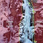
It’s true. Baxter State Park, in northern Maine, has a registration process and a set of rules that rival just about any other climbing area in the country. It ensures that properly equipped teams of climbers have a thorough knowledge of just what their getting themselves into. Although it might not be the intent of the park, it also contributes to the relatively small number of ice climbers who visit this amazing alpine playground. 

Contacting the Park and requesting their Winter Procedures and Information packet is the first step in putting a trip together. This free information will bring clarity to the winter party application process, the camping reservations, and the required equipment list. Most of the information in this packet is also available on the Parks website, www.baxterstateparkauthority.com

Building the Team

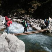
One of the major obstacles involved in climbing Katahdin must be tackled well before the mountain is even in view. It’s no small feat to assemble a group of four or more individuals (the minimum team size that the park will allow is four) that are willing to make the trip a priority. Scheduling conflicts, ability levels and transportation solutions are just a few of the many logistic details to contend with. Start by selecting a trip leader. This individual should begin the process of gathering information and communicating with Baxter State Park four to six weeks prior to visiting the peak.

When to go?

The next piece of the puzzle will be scheduling the actual trip. The length will be affected by many personal variables but six to eight days would be ideal. Depending on where you’re coming from, you’ll want three to four days just for travel. This includes traveling to and from the park, plus the 24 mile round-trip ski tour. Another three to four potential climbing days make the overall investment worthwhile. Because of the extensive planning involved, you’ll most likely be choosing the trip dates well before Mother Nature reveals her winter plans for the area. Snow pack, precipitation, temperature, and wind play a large role in the daily route conditions as well as the approaches and descents. Most of us here in the Northeast have grown accustom to scoping route conditions from the warmth of our vehicles. We don’t like the look of a particular climb; we drive to the next pull-out and check out something else. On Katahdin, be prepared to spend some time waiting for the weather to cooperate with your intentions. Teams who are able to schedule their trips in mid to late season will have longer hours of daylight, a substantial snow pack for the ski tour, and potentially milder temperatures.

Gearing Up

Once the team is assembled and the dates locked in, thought should be given to the mound of equipment that you’ll need. For a list of the mandatory gear, visit the Park’s website and look under the Winter Visitor Rules and Procedures section or check out the extensive chapter on Katahdin in An Ice Climber’s Guide to Northern New England by Peter Lewis and Rick Wilcox.

Instead of repeating the information found above, I decided to use the space for offering ideas and a few tips concerning some of the individual pieces of equipment.

pam ice cliffSleds

The benefits of hauling a sled usually outweigh the drawbacks. This is especially true when the majority of the terrain on the approach to Chimney Pond is perfect for hauling. Most climbers will carry a pack and drag a sled with a duffle bag in it to contain the load being hauled.

Making a sled is relatively cheap and easy. Below are two links that you might find useful in designing and constructing your rig.

TimHorvath_waterfallpitch1

Skis

There are two basic schools of thought here. The first one involves the use of Alpine Touring (A.T.) skis, bindings and plastic double boots. This set-up’s main advantage is that your climbing boot will work for the ski approach. The second option consists of using a lighter set-up all together. Backcountry skis, bindings and boots usually offer a significant savings in weight. Although both will work, it will pay to figure the pros and cons of each set-up. For the ski tour involved with climbing Katahdin, a set of lightweight backcountry skies with metal edges and flexible backcountry ski boots would work fine. The Tote Road up to Roaring Brook Campground receives a lot of snowmobile traffic from the rangers who use the winter months to shuttle supplies and materials. So this eight mile section can very easily resemble a groomed cross-country trail with many small climbs and enjoyable downhill’s along the way. I know what you’re thinking… this means carrying another set of boots for the technical climbing. I justify this by realizing the benefits of the lighter skis and boots that will be shuffled thousands of times on the approach. Plus the added advantage of keeping your climbing boots totally dry until you start the climbing.  Whatever set-up you choose, a pair of skins will be useful for the final three miles to Chimney Pond.

Snowshoes

Even if you plan to ski, which is by far the best way to go, consider bringing snowshoes. The last 3.3 miles to Chimney Pond climbs 1400 feet. Add the steeper terrain with the extra traction needed to haul a sled and some climbers might be more comfortable with snowshoes. Another situation where snowshoes might be a bonus is during the approaches and descents from the actual climbs where post-holing can be a harsh reality. If nothing else, consider bring them to the trailhead and making your decision there after talking to the rangers or getting a current conditions report.

chimney 1

Bunkhouse, Tent or Lean-to?

For those willing to pay the extra cost of sleeping in the bunkhouse at Chimney Pond you’ll have a warm, lighted, dry place to spend your evenings.  Just be sure to make your reservations as soon as possible to ensure availability. The other options include sleeping in one of the traditional three sided lean-tos or in your tent. Because each designated camping site has a lean-to as well as space to pitch a tent, using the two in combination seems to be the norm. The lean-to provides plenty of space for cooking, gear storage, and hanging out. Making the extra-large 4-season mountaineering tents overkill. Save weight and bring a smaller 4-season tent that’s just big enough for sleeping. Snow walls can also be built in front of the lean-to opening to provide better protection from the wind and snow. A lightweight 10’ x 8’ tarp might also work, just be sure to leave adequate ventilation for the stoves.

Vapor Barrier Socks

If you’ve never used VB socks before, now might be the time to experiment. The initial ski tour will generate enough foot sweat to saturate your boots on just the first day. And keeping moisture in check is the first step to alleviating frozen boots. Unless you’re staying in the heated bunkhouse, you’ll want to be overly concerned with keeping things like clothes, boots, ropes, etc. as dry as possible. The main thing here is to experiment before your trip. I usually grab a dozen produce bags from the grocery store and sandwich them between a pair of liner socks and a pair of thicker insulating socks. Don’t expect to get more than a day of use from these super thin bags, but they do the trick.

BenKurdt_AndyGilpin_Knifeedgetraverse

Water and Food

Water is usually available at both the Roaring Brook and Chimney Pond camping areas. So factoring in fuel to melt snow shouldn’t be an issue. The rangers at Chimney Pond cut a hole in the ice to scoop water out of. MSR Dromedaries make hauling larger quantities of water back to camp easier. Bury any unused water in 10” to 12” of snow overnight in covered pots for use in the morning. The insulating properties of the snow will keep the water from freezing, although you might get a thin layer of surface slush.

Pine martens, the weasel like creatures that live around Chimney Pond, should not be underestimated. These things can grab your food bag and drag it down one of their many deep lairs below the lean-to faster than you can shred a new pair of gaiters. In a few short minutes, we lost 24 sausage patties, numerous packets of GU, some crackers and a cell phone. Although the cell phone was later found deep in another stuff sack it was a devastating loss none the less. Hang your food! Even if you’re only leaving it for a few minutes use the nails in the lean-tos. There is a cable and hook type set-up located in the middle of the camping area for overnight hangs.

The Rack and Ropes

The perfect alpine rack seems akin to those mythical creatures like Big Foot or the Yeti – people swear they exist but I’ve never seen one. That being said, here is a general list of stuff for each rope team.

Bring 10 to 12 sharp ice screws, a few more if you like to keep the run-outs to a minimum. Keep in mind this is alpine terrain (i.e. no trees) so you’ll be using a portion of your screws for belays.

Assorted slings and biners

Unless you’re planning on tackling a mixed or thin ice route that requires rock gear, you can get away without bringing a substantial rock rack. A couple of pins, six assorted nuts, and two to three assorted cams up to 2” should be plenty for supplemental rock placements.

In my opinion, 60 meter dry treated half ropes provide more security and easier retreat options than a single rope system.

While most routes are climbed to the top and then walked off, rap rings along with webbing and a v-thread device should definitely be kept close at hand. Don’t plan on finding established rap anchors if the need to bail arises.  Practice your v-threads beforehand on frozen wind blown lakes or at the base of obscure ice routes.

knife edge 1

The Climbing Rangers

These guys are probably your best resource for up to date information but they can be hard to track down until you’re actually in the Park. The ranger cabin at Chimney Pond has a small collection of resource books, as well as the current third edition of Lewis and Wilcox’s guide to Northern New England. A weather report and forecast for the mountain is also available from the rangers on a daily basis. It’s a good idea to stop by the ranger station in Millinocket for detailed trail reports, directions to the trailhead and parking information.

Pre-Trip Preparations

Before any extended trip, especially those involving winter camping and climbing, it’s a good idea to do a few system checks. Take your newly designed sled out for a test drive. Go skiing and practice putting on and removing your skins. Fire up that new stove a couple of times. Ignore those convenient tree belays so common on Northeast ice routes and get proficient in building gear only anchors. Review rope signals. Learn about snow pack stability and the factors that increase avalanche activity. Last but definitely not least, go climbing on really cold days. These are just a handful of things that will contribute to your overall experience and success on Katahdin.

Off Mountain Information

Millinocket is a pretty small town. It does have a Hannaford grocery store, a McDonalds (located near the ranger station), Rite-Aid pharmacy, and a handful of restaurants, bars, and gas stations. A few hotels in the town are able to be booked using online reservation sites. The Appalachian Trail Café, on the main street in Millinocket has good food, big servings and really great prices.

If you’re traveling to Baxter State Park from the south, you’ll pass right by the town of Freeport, Maine which has North Face, Patagonia and Cloudveil outlets right in a row. As well as the L.L. Bean store which is open 24 hours a day, 365 days a year.  You might find great deals on clothing, skis and snowshoes but don’t expect to find much technical climbing hardware.

Want more Information?

Check out the following books for specifics on routes, great pictures and other useful advice.

An Ice Climber’s Guide to Northern New England by Lewis and Wilcox

Selected Climbs in the Northeast by Lewis and Horwitz

DeLorme’s Map & Guide to Baxter State Park and Katahdin

Rock and Ice Magazine Mountain Guide Special Issue No. 123

F.A.Q.

What does “a minimum of four people in a climbing team” actually mean?

A ranger explained it to me this way – Baxter State Park will only allow teams of four to ten people to venture above tree-line. This doesn’t mean that all members of the team must climb together on the same route. An example: two members of your team climb the Waterfall Route and two members climb an adjacent route like the Cilley-Barber. Both rope teams must have a shared knowledge of the others intentions, such as descent plans, turn around times, etc. Although if the rangers sense you might be stretching your teams limits, they will probably suggest a more conservative option.

Do I really need to bring a saw and an axe?

Yes. Gerber makes a pretty light weight short camp axe. For the saw, find what’s called a cable saw; its super compact and weights considerably less than most small camp saws.

How much climbing can I expect to actually get in?

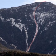
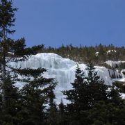
Depending on the weather, your team might get shut down completely or have the opportunity to climb a few classics. Even if the conditions keep you off the longer routes, there are a few days worth of climbs on the lower Pamola Cliffs. To give you and idea, we spent four nights at Chimney Pond and climbed the Waterfall Route, the Chimney with a traverse of the Knife Edge to summit, and a couple routes on the lower ice cliffs.

Is it worth it?

Without a doubt yes! The planning, the expenses, the details and the travel are worth the chance to climb some of the Northeast’s greatest ice routes. Standing on the frozen surface of Chimney Pond and looking up into the South Basin by the light of countless stars is a memory that will replay in my mind for what I hope is a very long time. Good luck!