Mahoosic Notch, Maine

Off the Beaten Trail

by James Paradis

MahoosucNotchFeb14-2010Over the past several years, Dan Cousins, Dave Custer, Jim Paradis, and Susan Ruff have extensively explored the ice climbing in Mahoosic Notch on the Appalachian Trail at the border of New Hampshire and Maine and climbed some 40 pitches of ice there. We find the ambiance in Mahoosic Notch in winter conditions to be unique in its wildness and big mountain scale and hope that the area will continue to foster a sense of adventure in those who choose to make the considerable effort to get there.

Mahoosic Notch Ice Guide  by Dave Custer

__________________________________________________________________________

Get A Job – 1/3/10

Matt-Mccormick-get_a_job_1-3-09b

Matt McCormick on “Get a Job”. Poke-O-Moonshine, Adirondacks NY  1-3-2010
Photo by MGB-VT

New winter rules for Katahdin

Baxter State Park, Maine

Baxter_south_basin-AOCSolo climbers allowed, no minimum group size

Great news! I am packed and ready to go. Maybe I can find some ice up there.

See the park web site for more information. winter rules and regs and the NEice forum for discussion.

Source: post by greenmtnboy

Photo: South Basin from Chimney Pond by AOC

More info from apaulcalypse:

I just got off the phone with Baxter State Park (not sure if it was a ranger, just whoever picks up the 207.723.5140 phone line). According to the woman I spoke with,

a) There is no ‘gear inspection’ on arrival. You do not need to, say, have every item on a checklist, and the rangers will not deny you climbing based on what’s in your pack.

b) Climbing on Katahdin CAN still be closed down in bad weather. I asked for some examples of what constitutes ‘bad weather,’ and she listed wind chills significantly below 0, whiteouts, high avalanche danger, “things of that nature.”

c) Yes, you can climb any route as a party of two. There is no longer a minimum team size.

d) As far as she was aware, there were no designated start / end times for climbs; that is, you can climb whenever you want. She did caution that is inadvisable to be out climbing after the sun goes down, though.

e) Ropeless, technical, free-solo climbing IS allowed. If you want to hike or climb alone, there is a winter solo camping and climbing form to fill out, along with an itinerary. You can climb ropeless alone or with partners. There is no specific hardware rack required, just gear appropriate to the terrain.

– Also see the article By Steve Prettyman Winter Climbing on Mt. Katahdin


Resources for Climbers

The American Alpine Club provides new electronic
resources for climbers

(GOLDEN, COLO.) – The   American
Alpine Club (AAC) today (Aug. 11,2003) announced the launch of a
powerful new web resource that provides outdoors
people with access to the catalog of one of the
world’s largest outdoor libraries.
The new on-line accessible database allows access to
18,200 books, journals, guides, and instructional
videos. It offers several search options including
browsing through the entire collection, or by specific
authors, titles, and subjects.
For example, entering in
the word “Yosemite” brings up 143 listings, with
hyperlinks to more detailed descriptions about
available books, videos, and journals. With the AAC’s
long-distance lending privileges, AAC members may use
the online search option to find items that they can
then have sent directly to their door.
The American Alpine Club
Henry S. Hall, Jr. Library has one of the most
extensive collections of mountaineering books, guides,
videos, and journals in the world. Currently there are
18,200 items, including rare books, one-of-a-kind
maps, and frequent new additions. The AAC Library is also
available for mountaineering or climbing research
questions. The Library’s strengths include Mount
Everest and the Himalayas, a diversity of guidebooks,
the Alps, and mountaineering history.
“The new searchable
database allows anyone to search the catalog of the
AAC library and discover sources of knowledge to help
them plan their next climb, trip, or expedition,” said
AAC Executive Director Charley Shimanski. “It makes it
easier for you to find titles in our library in Golden
than to find them on your own bookshelf.”
This new resource is
part of a redesigned website. The new site is easier
to navigate than the previous one and is full of
useful information on AAC grants, benefits, huts,
policy, publications, and rescue insurance.
Advantrics LLC
generously donated their time and resources to develop
the AAC’s new website. Advantrics is leading
the development of multimedia-based products and
designs for enhancing the presentation of information
on the Internet. Since 1998, Advantrics has acquired
and developed products and services to help its
customers find the right Internet solution.
About The American Alpine Club
The American Alpine Club
is a national 501(c)(3) non-profit organization that
has represented climbers for an entire century.
Founded in 1902, The American Alpine Club is dedicated
to promoting climbing knowledge, conserving mountain
environments, and serving the American climbing
community. The AAC currently has 7,200 members
throughout the U.S. and across the globe.
Contact: Jessica Meinerz

(303) 384 – 0110 ext. 18

jmeinerz@americanalpineclub.org

AMERICAN ALPINE CLUB
LIBRARY

Madison Gulf

The Presidential Range, NH

Of the UP! & Ova…….. aka; Holy F*%*!

by Alan Cattabriga

Madison Gulf from the approch

Madison Gulf from the approach

After leaving a car at the Appalachia parking in Randolph, Tim, Ted, Doug and I are on the Great Gulf Trail in Pinkham Notch by 7am. The plan is to hike into Madison Gulf, climb the route, “Point”, then continuing up to Adams summit and down the other side via the Airline Trail to Appalachia.

Temps are in the upper 30’s but the trail is packed and hard. We decide to leave the snowshoes at the car. ( big mistake ) We figured the only place we would need them would be for the bushwhack from the Madison Gulf Trail to the ice. The approach is packed & the descent would be for sure.

The day is bluebird. The trail nice but all too soon, about halfway in, the sweet trail conditions go south fast. Once on the Madison Gulf Trail it was no longer packed. There were savage spruce traps, very little good footing and to add more to it, we kept losing the trail. The snow is so deep you are up higher in the tree branches, where trails are not trails. Blazes were non-existent.

Our good pace went to a crawl. In some places, literally. Hours slipped by as we lost the trail, again & again. Back-tracking every time to where we knew we were on it and trying again. At last we were in line with the ice and could see it good… we made the straight plunge. 7hrs. had passed since our departure at the Great Gulf trail-head to the base of the routes. Holy crap…

Madison Gulf MapAt the ice wall the sun is warm, the ice is huge and beautiful. My feet are soaked. Sitting on a rock, I wring out the socks and let my boots air out for a bit. Next we have 300’+ of ice, another bushwhack to the Buttress Trail then up the open summit of Adams. The ice is pure fun, the bushwhack above, because of the deep, hard-ish snow, is quite easy.
At the Buttress Trail we split up, I head up awesome snow to Adams and the others for the Star Lake Trail & Madison Hut.

The Airline Trail from Adams summit is in excellent shape, and it’s “knife edge” section bare rock & alpine plants. I lounge here for awhile wondering if I’m ahead of the gang. I decide ( mainly due to soaking wet feet) to book it down.

11hrs. 50mins after leaving, we are all down…. what a day! I’d go back in a heartbeat too.


Photos by Alan Cattabriga, & Doug Millen.


Batchawana Bay-Agawa Canyon

Ontario, CA

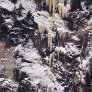
Ice Climbing North of Sault Ste. Marie Ontario in the Batchawana Bay-Agawa Canyon Area

by Shaun Parent

Located between half an hour and 1.5 hours north of Sault Ste. Marie adjacent to highway 17 this area hosts over 10 separate ice climbing areas.

In the area just south of Lake Superior Park in the vicinity of Montreal River Harbour are several easily accessible Ice climbing sites. Tower Road hosts over 30 short but steep ice climbs up to 10 meters in height. The road is plowed all winter so one can park a vehicle within 20 meters of the climbs.

Just a few minutes north short hikes of 15 minutes from highway 17 take climbers to the Panama Wall where there are 6 climbs up to 25 meters in height the most interesting of these is Aurora Borealis grade 4, 20 meters. Across the highway is the Ryall Wall, on which is found the spectacular “Mother of Pearl” a grade 3+ ice climb 20 meters in height.

For the more adventurous one can snowshoe or ski along Ranwick Road for 4 kilometers to Ranwick Rock, the site of summer rock climbing activities and a rock climbing guidebook. In the winter there are 8 ice climbs up to 100 meters in length. The access point for Ranwick is at the top of the Montreal River hill.

One area, which has received considerable attention in the past and should see complete development this season, is Cerro-De-Hielo (Mountain of Ice). Located 8 kilometers off highway 17 on the Carp River road at Batchawana. This area contains several individual climbing areas including the Transverse Mercator wall hosting THRESHOLD OF AQUAINTANCE Gr.4, 25 M. The Wall of Deception contains two excellent climbs JACOB’S LADDER Gr.4+, 30 M, and VERTIGO VENTANA a series of blue pillars and curtains rated Gr.4, 30 M high. The Wall of Sinn and the Wall of Sorrow shows promise for a minimum of 25 climbs of 20 meters in height and all in the Gr.4 to 5 ranges. The access road is supposed to be open all winter 2005 as logging is taking place in this area.

The Climbs of Mile 38 Road near the well know Chippewa Falls on highway 17 offers many enticing climbs. Located 4 kilometers down this plowed road from highway 17 the climb “BLUE AVENJURE” 100 M, Gr.3, saw 5 ascents by different parties within the first three days of its first ascent in 2002. It is one of the highest and most accessible ice climbs in the east shore of Lake Superior. The climb DUTCH TREAT Gr.4+, 50 M lies less then 150 meters from where vehicles are parked on Mile 38 road and gives two variations of climbing, one in a chimney choked with ice or a direct headwall.

Since the release of the AGAWA CANYON ICE CLIMBING MAP in 1999 and

“Superior Ice” guidebook in 2001 by Granite publishing many more climbers have taken an interest in this well known canyon located north of Sault Ste. Marie. Agawa Canyon has 54 climbs up to 200 meters in length along the 6 miles of canyon between mile 110 and 116. Climbers can enjoy the Algoma Central Railway passenger train service that will drop passengers off to enjoy winter camping at Mile 112 in the center of it all.

Ice climbers have during the winter of 2004 found access points to Agawa Canyon by snowmobile from the Frater Road. This access trail takes one to the edge of Agawa Canyon at Mile 110. Two new areas have been developed in this area, the “ONLY 17 WALL” and the “LIL-AGAWA CANYON” adds another 15 ice climbs to the area with routes up to 50 meters in length. The 2nd edition of the Agawa Canyon Ice climbing guidebook will be available in early 2005, and will include these new areas.

The second area mentioned in the “Superior Ice” guide, Montreal River (South Bay) at Mile 92 on the Algoma Central Railway has 10 climbs up 130 meters in length along a 1.2-kilometer wall of pristine granite. The favorite climb in this area is Comfortably Numb Gr.3+, 120 meters at Mile 92 (South Bay). One can access this are either by train or by snow machine.

A Reconnaissance expedition by snowmobile in January of 2004 up the Montreal River uncovered the SPK, Majestic and Mystic Walls. This face of granite is in excess of 4 kilometers long, and hosts what appears to be the Mid-Continents highest and most aesthetic ice climbs. The highest ice climb in the Mid-continent “STRATOSPHERE Gr.4, 260 meters is found here. Along the same face is the route RITE OF PASSAGE Gr. 4, 160 meters in length is an ice filled fault line. The TURQUISE COYOTE Gr.4, 70 meters and its upper section the EMERALD BOBCAT Gr.4, 50 Meters contain the largest mass of ice in the region. The main danger of accessing these climbs is the Montreal River Reservoir, which seldom freezes, and offers many large expanses of slush and open water throughout the winter months. Several snowmobiles were abandoned last winter in the slush, and one snowmobile went through the ice in the winter of 2003, but was rescued 10 minute later, loosing the machine.

This area is quickly gaining the reputation as a climbing destination for ice climbers in the Midwest and throughout North America, the height and aesthetic value of the climbs.

The local guidebook “Ice Climbs of The Batchawana-Montreal River Harbor areas is now in it’s fourth edition. It includes the climbs of the Montreal River Harbor Area, Cerro-De-Hielo and Mile 38 road. A fifth edition is due out in February 2005, and will contain over 100 ice climbs in 14 separate areas.

Photos, ice conditions, route information is posted frequently on www.climbingcentral.com in Rumor Central.

For ice climbing instruction, guiding, specific route beta, climbing guidebooks, gear rental and snowmobile shuttle service. Contact the North of Superior Climbing Company www.northofsuperiorclimbing.com info@northofsuperiorclimbing.com 705-946-6054

Lincoln’s Throat

Mt. Lincoln, Franconia Notch NH

by Doug Millen

Mt Lincoln NH

Mt Lincoln NH – “Lincoln’s Throat”

I have often looked over and speculated on what the climbing on Mt. Lincoln might be like. Fred Bieber and I went to find out. We were not disappointed.

[nggallery id=2]

How to get there

Take 93 North to Franconia Notch. Park at the trail head parking just after the Basin parking or at the Lafayette Camp Ground. Hike the Old Bridal Path till you are in line with the gully (see 1st photo). Bush wack down through thick spruce to the brook. Cross the brook and head up the right drainage. Follow this drainage till you hit the basin then take the right drainage to the summit. Follow the ridge trail right to Haystack Mt. and descend the Falling Waters trail. It’s about 9 miles round trip.

[mappress]

When to go?

Early winter before the snow get too deep. The gullies are subject to avalanche danger, be careful.

How much climbing can I expect to actually get in?

About one pitch of WI3 ice. If you are looking for lots of ice, this is the wrong climb. This climb is about getting away from the crowds and climbing a mountain.

Is it worth it?

Absolutely! No trail, road traffic or other climbers. I felt like I was walking up some big drainage out west. Great views all day and you top out at 5000 ft.  A great leg work out and a great adventure. This is a remote climb so act accordingly. Enjoy!


Mt-Lincoln-nh-wide view

Moody Aunt Ruby

Lake Willoughby, VT

Moody Aunt Ruby (WI 6 R/X, 110M) – Will Mayo, Joe Szot & Ian Boyer
MoodyAuntRuby

Photo by Doug Millen

Across the Lake on Mt. Hor, Joe Szot, Ian Boyer and I climbed the ethereal yellow icicles that hang from those compact limestone cliffs today, 12/13/2005, naming the route. Arriving at the base of the cliff with the temperature not much above zero and racking up above the southward rolling fog along the surface of the open waters below after having traversed the entire south end of the Lake, I realized that I had left the rock rack in the Flying Brick (my van).  I asked the boys with a straight face, “Okay, who’s got the rock rack?”  But, they knew the mistake was mine.  My punishment was to lead the thing with only ice gear, which made things rather run-out. The first 60M pitch was the crux and involves a hollow vertical column of ice to a ramp to attain the golden double-tiered free-hanging icicles that hang above.  These daggers of ice were the cruxes and required launching up gymnastically onto the hangers with gear well below.  Joe Szot climbed the 50M WI 5 second pitch up mushroomed ice to a tier of free-standing columns and reached the trees.   Moody Aunt Ruby was climbed on-sight in “ground up” style and was yet another in a string of phenomenally exciting days of ice climbing with close friends.  Moody Aunt Ruby is definitely one of the most exciting ice climbs I have ever done.

-Will Mayo

NOTE: This Route is Reportedly to have been climbed before by either Barry Blanchard or Kurt Winkler. The information is unclear and no details are available at this time.